|
||||
|
||||
|
![]()
![]()
![]()
![]()
![]()
![]()
|
||||
|
||||
|
![]()
![]()
![]()
![]()
![]()
![]()
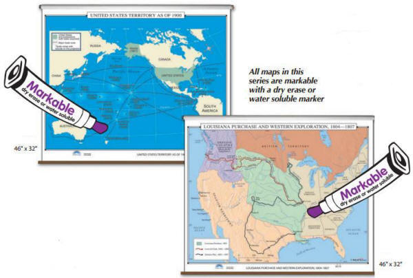 Durably laminated classroom wall maps measure 46" x 49". Easy to read, printed on tough non-tear material, brightly colored, and markable with dry erase or water soluble markers. From a map featuring possible migration routes of the first Americans to a map of the Gulf War, all maps in this series meet US history curriculum requirements. Save money and space by mounting US History wall maps together, as a set, on one spring roller-mounted wall map operation. All history maps are eligible for inclusion in custom made map sets. Wall maps are ideal for history buffs as well as for public, private, parochial, and home schools. Wall maps can be ordered as multiple map sets or as single maps.
If ordering a set, please indicate map item number and title in the Special Instructions Section of the secure Shopping Cart below. |
|||||||||||||||||||||||||
|
Use COUPON CODE "10NOW" for an additional 10% DISCOUNT for multiple Map Sets Only |
|||||||||||||||||||||||||
|
To order single history maps please use "Add to Shopping Cart" buttons next to each map (arranged by approximate dates) |
|||
|
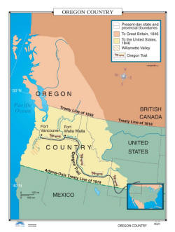
Oregon Trail -
US History Wall Map Item # 30062 Sale: $84.99 - $329.99 (free ship/h) The Oregon Country wall map identifies present-day state and provincial boundaries; British Canada, as of 1846; the part of the Oregon Country controlled by the United States in 1846; the Willamette Valley; and the Oregon Trail. |
 |
|
|
|
|
|||
|
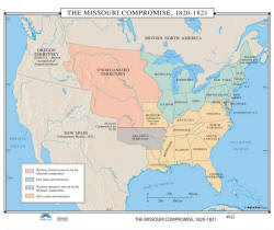
Missouri Compromise - US History Wall Map Item # 30065 Sale: $84.99 - $329.99 (free ship/h) The Missouri Compromise, 1820-1821 identifies, in color, territory closed to slavery by the Missouri Compromise; free states and territories; territory opened to slavery by the Missouri Compromise; and slave states and territories. |
 |
|
|
|
|
|||
|
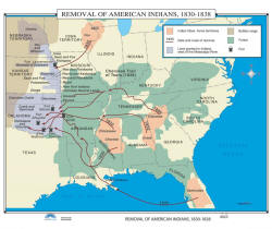
Removal of Native Americans - US History Wall Map Item # 30068 Sale: $84.99 - $329.99 (free ship/h) The Removal of American Indians, 1830-1838 identifies the Indian tribes’ home territories; the date and routes of removal; land granted to the Indians, west of the Mississippi River; buffalo ranges; forests; and forts. |
 |
|
|
|
|
|||
|
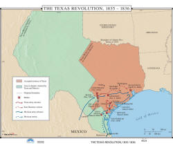
Texas Revolution - US History Wall Map
Item # 30071 Sale: $84.99 - $329.99 (free ship/h) The Texas Revolution (1835-1836) wall map identifies the accepted territory of Texas and the area in dispute – territory that was claimed by Texas and Mexico. |
 |
|
|
|
|
|||
|
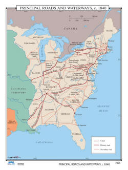
Transportation Routes - US History Wall Map Item # 30074 Sale: $84.99 - $329.99 (free ship/h) The Principal Roads and Waterways in 1840 are identified by solid and broken lines. Shows canals, primary roads, and secondary roads in the area between the Mississippi River and the Atlantic Ocean. |
 |
|
|
|
|
|||
|
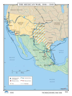
Mexican War - US History Wall Map Item # 30077 Sale: $84.99 - $329.99 (free ship/h) The Mexican War of 1846-1848 wall map features three main areas: Mexico, the land ceded by Mexico in 1848, and the area disputed by the United States and Mexico. Shows American and Mexican force movements and victories, forts, and blockades. |
 |
|
|
|
|
|||
|
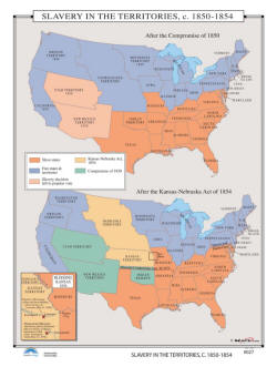
Status of Slavery in the Territories 1850 to
1854 - US History Wall Map Item # 30080 Sale: $84.99 - $329.99 (free ship/h) Slavery in the Territories, 1850-1854 provides comparison maps showing slavery territories. The first map shows slavery territories after the Compromise of 1850. The second map shows slavery territories after the Kansas-Nebraska Act of 1854. As an added feature, there is an inset map showing Kansas in 1856, and highlights the Potawatomi Massacre. |
 |
|
|
|
|
|||
|
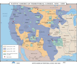
Native Americans Land Losses, 1850 to 1890 - US History Wall Map Item # 30083 Sale: $84.99 - $329.99 (free ship/h) Classroom wall map identifies Native American Territorial Losses, 1850-1890, and shows land lost prior to 1850; land lost from 1850-1870; land lost from 1870-1890; Native American reservations, as of 1890; and major battles. |
 |
|
|
|
|
|||
|
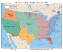
United States Expansion in 1853 - US History Wall Map Item # 30086 Sale: $84.99 - $329.99 (free ship/h) The Growth of the United States to 1853 wall map includes shaded areas showing the original thirteen States, Louisiana Purchase, Texas annexation, Oregon country, Mexican cession and the Gadsden Purchase. As an added bonus, this overview map shows an outline of modern state boundaries and names for reference. |
 |
|
|
|
|
|||
|
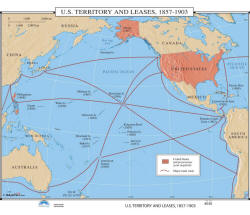
US Lands - US History Wall Map Item # 30089 Sale: $84.99 - $329.99 (free ship/h) The US Territory & Leases, 1857-1903 wall map shows the United States and possessions, with the year acquired. Also shows major trade routes. |
 |
|
|
|
(1) 35,000 BC - 1776 AD (2) 1776 - 1812 (3) 1846 - 1857 (4) 1860 - 1877 (5) 1870 - 1941 (6) 1949 - 1999 (7) Wars Abroad |
|||
|
|
|||
Call us toll-free 877-822-9889 or 812-333-2772 for orders/questions Mon.-Sat. 10:00 am-5:30 pm Eastern Standard Time
United States 19th Century History Pull Down Classroom Wall Maps on Rollers by KP, Item # 302xx
Sale Price: $84.99 - $329.99, Educational pull down world maps for students of history, classroom maps on rollers, school maps, spring roller maps, roll down maps for classrooms, large world maps
|
Home | Products | About Us | Contact Us | Helpful Links | Return and Privacy Policies | Site Map | International Orders |
||||||||||||||
|
|
|||||||||||||
|
Site Map | Privacy Policy | Easy Return/Exchanges | APO/FPO Orders | No Minimum Order + FREE Shipping (contiguous USA) |
||||||||||||||